 Daniel Hofbauer
9056a30d8f
* fix(services): let WMS and CSW forms accept same-origin relative endpoints

Service forms only rejected relative URLs for the WMS and CSW kinds: both
validated with an absolute-http(s) check before building requests, which
blocked deployment-configured entries pointing at reverse-proxied services
(/geoserver/wms, /catalog/csw). Introduce isServiceFormUrl (absolute http(s)
or a same-origin reference), use it in both forms, resolve relative CSW
endpoints against the document origin, and keep relative WFS/XYZ discovery
out of the absolute-only Vite CORS proxy.

* feat(services): add a runtime-configured deployment service library (#2457)

Self-hosted deployments can now extend the built-in service library at
runtime instead of maintaining a fork: a startup-provided catalog
(VITE_GEOLIBRE_SERVICES) is merged as read-only entries that appear in the
Browser and every Add Data service picker, are marked 'config' in all
catalogs, are never stored in localStorage or exported, and cannot be edited
or deleted. GEOLIBRE_BUILTIN_SERVICES=off (published by the entrypoint) hides
the built-in starter presets while keeping configured and personal entries.

* feat(docker): publish the deployment service catalog and built-in toggle

The entrypoint reads an optional mounted GEOLIBRE_SERVICES_FILE on every
container start, validates it strictly (nonblank id/name, known kind,
nonempty primitive fields, unique ids; entry-indexed boot errors), and
publishes it as VITE_GEOLIBRE_SERVICES in the runtime config, so a prebuilt
image is repointed by restart alone. GEOLIBRE_BUILTIN_SERVICES=off hides the
built-in starter presets; any other value fails the boot. The service worker
stops precaching geolibre-runtime-config.js so deployment changes never get
pinned to a build revision.

* fix(services): address PR #2463 review findings

- Reject protocol-relative URLs in isServiceFormUrl: they share only the
  scheme, not the origin, and would bypass the dev CORS proxy.
- Reject relative WMS/CSW endpoints on the desktop (Tauri) build with the
  translated URL message; the native HTTP path requires an absolute http(s)
  endpoint. Also guard the Browser apply path so it no longer surfaces the
  raw 'Invalid WMS tile URL.' throw.
- Resolve relative CSW endpoints against window.location.origin instead of
  the full href, so route-relative entries are path-independent.
- Reject integers beyond JavaScript's safe range (2^53-1) in the entrypoint
  catalog validation: they would become Infinity or round during JSON.parse.
- Fix the Thai config label (Bengali codepoints) and translate the Dutch
  label to geconfigureerd.
- Docs: clarify that startup validates structure only (the forms validate
  kind-specific fields when applied), list every kind's field shapes, mention
  the safe-integer bound, and fix the broken getting-started link from
  docs/user-guide.

* fix(services): reject scheme-only URLs and precise safe-integer wording

Apply the second CodeRabbit pass on #2463:
- isServiceFormUrl now parses absolute http(s) candidates, so scheme-only
  values like 'https://' fail at the form with the translated error instead of
  throwing from new URL() in the request builders (web and Tauri alike).
- The entrypoint's field error and docs now state that finite numbers are
  allowed and only integers must be within the safe-integer range (2^53-1).
14 KiB
Adding Data
The Add Data menu is the main way to bring layers into GeoLibre. It groups sources into Files, Web services, Cloud formats, 3D layers, and Databases. You can also drag files straight onto the map.
For a consolidated list of file formats, service protocols, and platform limitations, see Supported Data Formats.
To collect supported dataset links from a catalog or other webpage and open several at once, use the GeoLibre Chrome extension, available from the Chrome Web Store.
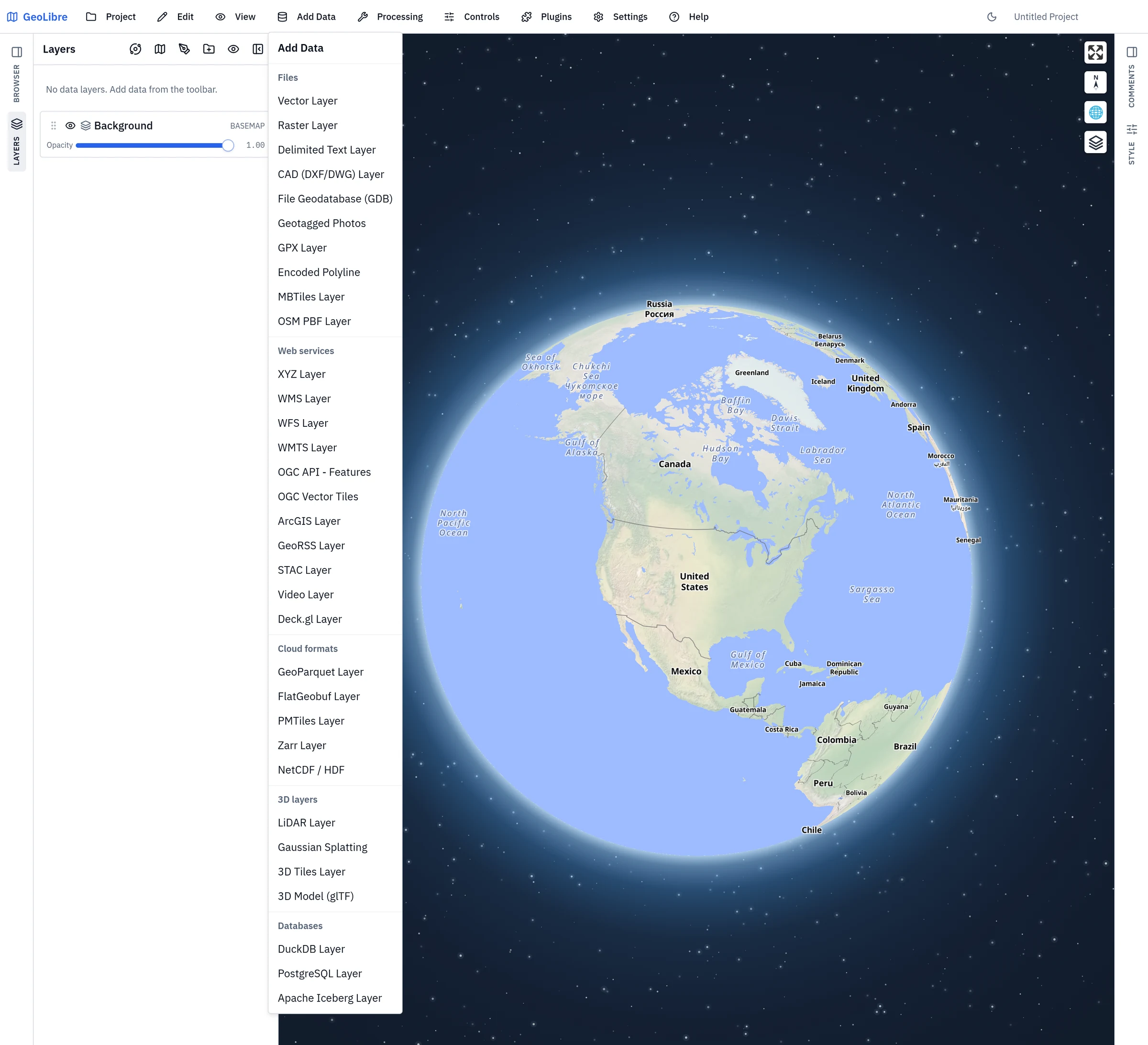
Files
| Item | Notes |
|---|---|
| Vector Layer | Opens the Add Vector panel (backed by maplibre-gl-vector). Loads GeoJSON, GeoParquet, FlatGeobuf, zipped Shapefile, GeoPackage, KML/KMZ, GML, and other vector formats from a file or URL. |
| Raster Layer | Opens the Add Raster panel (backed by maplibre-gl-raster). Loads GeoTIFF and Cloud-Optimized GeoTIFF (COG) from a file or URL. |
| Delimited Text Layer | Loads CSV/TSV from a file or URL, using longitude and latitude columns to build point features, or by geocoding one or more address columns (see Geocoding). |
| CAD (DXF/DWG) Layer | Loads AutoCAD drawings, converting their entities to vector features. |
| File Geodatabase (GDB) | Opens an Esri file geodatabase and adds one of its feature classes as a layer. |
| Geotagged Photos | Reads the EXIF GPS tags from a set of photos and places each one on the map as a point with a thumbnail. |
| GPX Layer | Loads a GPX file or URL and splits it into separate waypoint, track, and route layers. |
| Encoded Polyline | Loads Google (precision 5) or Valhalla/Mapbox (precision 6) encoded polyline strings from pasted text or uploaded text files. |
| MBTiles Layer | Loads a local MBTiles tile archive (desktop app). |
| OSM PBF Layer | Reads an OpenStreetMap .osm.pbf extract and adds the features you select from it. |
Vector files are reprojected to EPSG:4326 on load. In the browser, vector import relies on DuckDB-WASM Spatial, with direct handling for GeoJSON, zipped Shapefiles, and KMZ archives. The source CRS is read from the file itself — the layer metadata for the GDAL-read formats, a Shapefile's .prj sidecar, or a GeoParquet's geo metadata — so a national grid such as EPSG:2100 (GGRS87 / Greek Grid) lands in the right place with nothing to configure.
GeoParquet opens across its variants: 1.0 and 1.1 files (including one carrying a declared covering bbox column), 2.0 files using the native Parquet GEOMETRY/GEOGRAPHY types, and plain Parquet whose geometry is only a WKB blob under a conventional name such as geom. The geo metadata block decides which column holds the geometry and what CRS it is in, so a file with several geometry columns loads the one it declares as primary; a file declaring "crs": null is stating that its coordinates are in no known reference system, and is drawn as it stands with no transform applied. A Parquet table with no geometry at all but a pair of lon/lat (or longitude/latitude, lng, x/y) floating-point columns loads as points, assumed to be WGS84.
!!! warning "Large vector files"
There is no fixed size limit. Files under 100 MB are read by the
in-memory JavaScript readers, which are fastest for everyday data. At
100 MB or larger, GeoLibre streams the file through DuckDB instead —
off the main thread, so the interface keeps responding. For a zipped
Shapefile the threshold applies to the uncompressed .shp, since
shapefiles compress heavily and the archive's size says little about the
parse cost. This happens automatically; nothing is asked of you.
A separate check counts features once the source is open. Past
**100,000 features**, GeoLibre asks before converting every one to GeoJSON
in memory, because that is where memory rather than file size becomes the
limit — a small GeoParquet can hold millions of rows.

For very large data, converting first still pays: **Processing → GeoLibre
Toolbox → Conversion → Vector to PMTiles** writes a tiled format the map loads one tile at a
time instead of reading the whole file. Converting to **GeoParquet**
instead gives a compact columnar format that reads far faster than text,
though it is not tiled. GeoJSON is the most expensive option at any size —
it expands several-fold in memory — so prefer a Shapefile, GeoParquet, or
FlatGeobuf source when you have the choice.
!!! tip "KML and KMZ" KML is read by an in-house parser that keeps the file's own symbology, so styled KML renders the way it does in Google Earth. A file that parser cannot handle falls back to the DuckDB Spatial reader, which loads the geometry without the styling.
KML imports also render `GroundOverlay` images as map overlays (which animate through the Time Slider when they are time-tagged) and show embedded Collada `.dae` models. **Super-Overlays** — the tiled, `NetworkLink`-driven KML that large imagery exports use — are supported too: GeoLibre serves the archive's tiles to the map instead of trying to load the whole pyramid at once.
Web services
| Item | Notes |
|---|---|
| XYZ Layer | A raster or vector tile service using a {z}/{x}/{y} URL template. |
| WCS Layer | Downloads numerical GeoTIFF subsets from WCS 1.0.0 services. |
| WMS Layer | A Web Map Service layer, with click-to-identify through GetFeatureInfo where supported. |
| WFS Layer | A Web Feature Service layer, with optional automatic refresh. |
| WMTS Layer | A Web Map Tile Service layer. |
| OGC API - Features | An OGC API - Features endpoint; pick a collection and add it as a vector layer. |
| OGC Vector Tiles | An OGC API - Tiles vector tile service. |
| ArcGIS Layer | An ArcGIS FeatureServer, VectorTileServer, MapServer, or ImageServer layer. See ArcGIS services. |
| GeoRSS Layer | A GeoRSS feed, added as points and lines with the feed's titles and descriptions as attributes. |
| STAC Layer | Searches a STAC catalog and adds the matching raster items. |
| Video Layer | Drapes a video over four map corner coordinates, the way MapLibre's video source does. |
| Deck.gl Layer | Renders a deck.gl layer specification over the map, for visualizations MapLibre's own layer types do not cover. |
ArcGIS services
Pick the Layer type that matches the service, then give it a service URL or a portal item ID (with an access token for a secured service).
| Layer type | Service | How it loads |
|---|---|---|
| Feature layer | FeatureServer | Downloaded page by page as a GeoJSON layer, so labels, the attribute table, identify, symbology, and export all work on it. |
| Vector tile layer | VectorTileServer | Rendered from the service's own style. |
| Map service | MapServer | A raster layer. Cached services are read as tiles; dynamic ones are drawn per tile through /export. |
| Image service | ImageServer | A raster layer drawn through /exportImage (or the service's tile cache). |
Map and image services become ordinary raster layers, so opacity, the Style panel's brightness/contrast/saturation controls, reordering, and saving to a project all work on them.
Two optional fields shape what the service draws:
- Sublayers (map service) takes the sublayer ids to draw, such as
0,2,5. Leave it blank for the service's own default set. Pasting a URL that ends in a sublayer id (.../MapServer/3) selects that sublayer for you. - Raster function (image service) can be selected from the functions the
service advertises with Browse functions. The selected function is applied
by the server before the image is sent. The Rendering rule field
remains available for advanced Esri raster function JSON. For example,
{"rasterFunction":"Hillshade"}selects the Hillshade function.
Either choice draws the service dynamically, because a cached service's tiles were rendered before the choice existed and cannot honor it.
Cloud formats
| Item | Notes |
|---|---|
| GeoParquet Layer | Cloud-native columnar vector format. Opens the same Add Vector panel as Vector Layer. Can be streamed in place with HTTP range requests for large remote files. |
| FlatGeobuf Layer | Cloud-optimized vector format with spatial indexing. |
| PMTiles Layer | A single-file vector or raster tile archive. |
| Zarr Layer | Chunked, cloud-native multidimensional arrays. |
| NetCDF / HDF | Multidimensional scientific data cubes, with a setup step for picking the variable and the time and vertical dimensions. |
3D layers
| Item | Notes |
|---|---|
| LiDAR Layer | Point-cloud visualization, rendered with deck.gl. |
| Gaussian Splatting | Gaussian splat scenes. |
| 3D Tiles Layer | OGC 3D Tiles, restored when reopening a project. Includes a Google Photorealistic 3D Tiles sample that reads VITE_GOOGLE_MAPS_API_KEY or GOOGLE_MAPS_API_KEY from the runtime environment. |
| 3D Model (glTF) | Places a glTF/GLB model at a coordinate, with scale, rotation, and altitude controls. |
Databases
| Item | Notes |
|---|---|
| DuckDB Layer | Query a DuckDB or DuckDB Spatial source and add the result as a layer, with identify, selection, and attribute table support. |
| PostgreSQL Layer | Add a layer from a PostgreSQL/PostGIS connection (desktop app, served through a local tile server). |
| Apache Iceberg Layer | Read an Iceberg table through DuckDB and add its spatial column as a layer. |
Drag and drop
Drag a vector file (GeoJSON, zipped Shapefile, KMZ, and similar) or a GeoTIFF/COG raster directly onto the map to add it as a layer. GPX files dropped on the map are split into named waypoint, track, and route layers.
The Browser panel
The Browser tab on the left edge of the window opens a QGIS-style Data Source Manager: a tree of everything you can add without going through a menu. Use it when you add the same sources repeatedly, or when you want to explore a service or a database before committing to a layer.
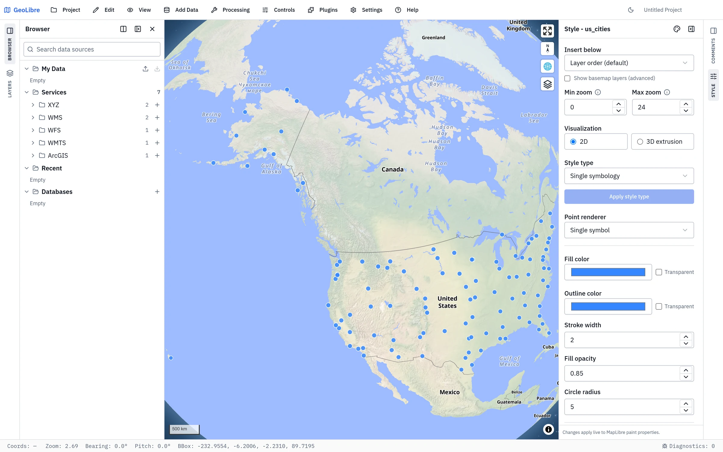
| Section | What it holds |
|---|---|
| My Data | Your personal layer library. Layer actions → Save to My Data stores a fully configured layer — source, style, labels, filters, joins, virtual fields, and attribute form — and one click here re-adds it to any later project. Import and export the library with the buttons on the section header. |
| Services | Saved map services, grouped by kind (XYZ, WMS, WFS, WMTS, ArcGIS). GeoLibre ships a starter set; the + on a group adds a new connection of that kind. Expand a service to browse its layers and add one. Self-hosted deployments can add read-only organization-wide services here, marked with a config badge (see Getting Started); they are shared with every user, cannot be edited or deleted, and are never stored in your own service library. |
| Recent | The sources you added most recently, so a repeat is one click. |
| Databases | PostGIS connections. Expand one to browse its schemas and tables; on a table that registers more than one geometry column, pick the column explicitly. |
Type in the search box to filter the whole tree, and navigate it entirely from the keyboard with the arrow keys.
Basemaps
The basemap sits at the bottom of the Layers panel as the Background entry. Double-click that row to open the Change basemap dialog, or activate the Basemaps plugin from the Plugins menu to switch between OpenFreeMap styles (Liberty, Liberty 3D, Positron, Bright, Dark, Fiord), a collapsible Regional group, a blank background, or a custom style URL. You can toggle basemap visibility and adjust its opacity from the Layers panel.
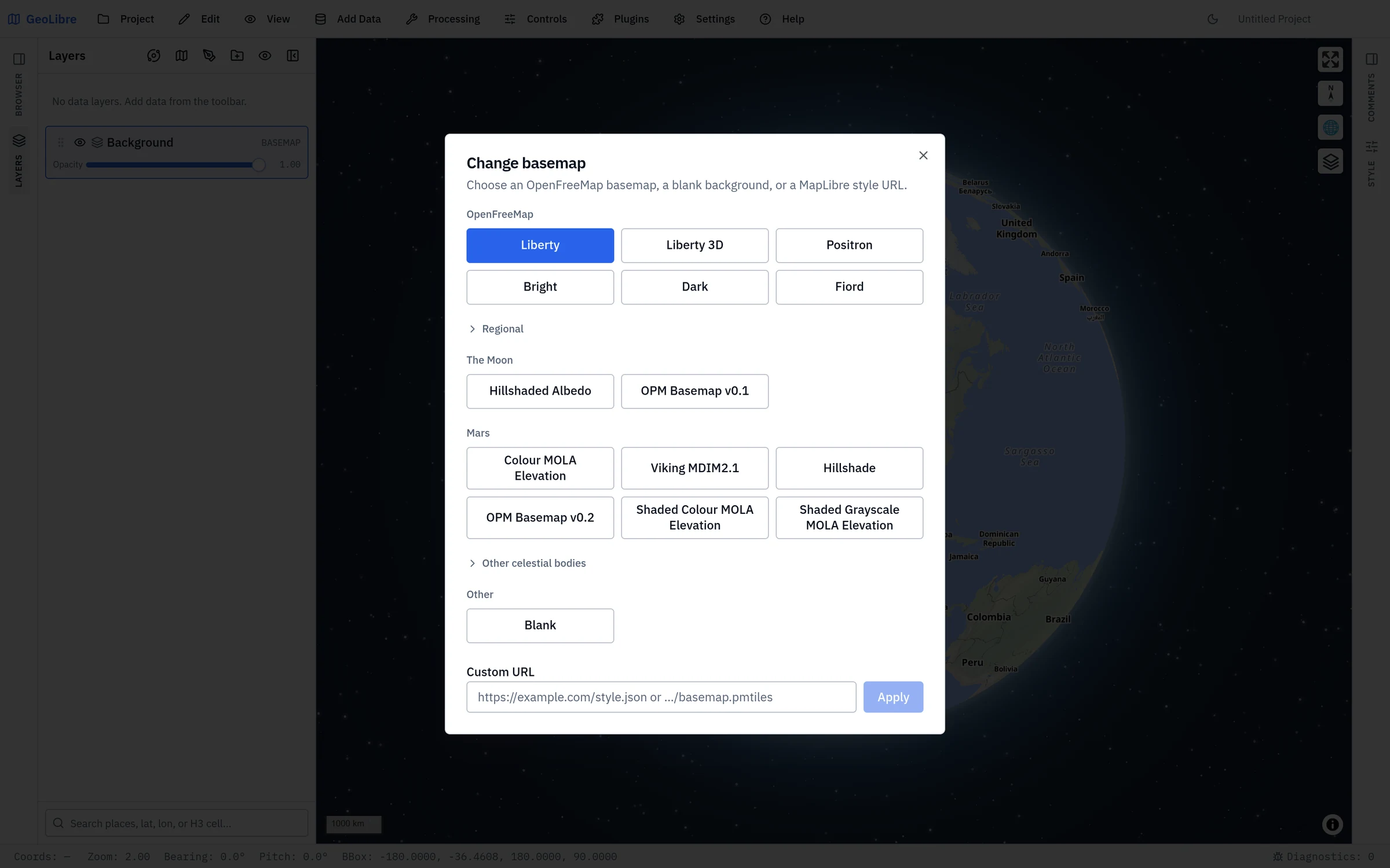
Other celestial bodies
GeoLibre can map worlds beyond Earth. The Change basemap dialog and the New project dialog group planetary basemaps into sections for The Moon, Mars, and a collapsible Other celestial bodies section covering Mercury, Venus, the Galilean moons (Io, Europa, Ganymede, Callisto), Titan, Pluto, and Charon. The Moon and Mars mosaics come from OpenPlanetaryMap; the other bodies come from USGS Astrogeology and are reprojected to Web Mercator on the fly so MapLibre can render them.
For quick switching, use the planet switcher (the orbit icon) in the Layers panel header. Selecting a body sets the project's ellipsoid, so distance, area, and scale-bar measurements use that body's radius instead of Earth's.
More data sources
Additional catalogs and providers are available as panels and plugins rather than Add Data items, including Planetary Computer, Earth Engine, Overture Maps, and several federal Web Services. See Data Integrations.
Three of them, grouped under Plugins → Web Services, search public dataset catalogs by keyword and add a result to the map in one click:
| Panel | What it searches |
|---|---|
| ArcGIS Hub | Public datasets published to ArcGIS Hub. Search by keyword or restrict the search to the current map area, page through results, add a supported layer to the map, zoom to it, or download the data. Datasets with several layers download only the first, and the panel says so. |
| Socrata | Public Socrata open-data catalogs, adding their GeoJSON datasets. |
| CKAN | The Humanitarian Data Exchange CKAN catalog, adding its available GeoJSON resources. |
Each panel shows how many of the total results you are looking at and offers Load more to page further. See Web Services for the other fourteen browsers in that submenu.
!!! note "Browser vs desktop" URL-based sources work in both the browser and the desktop app. Local file dialogs, local MBTiles, local raster reads, and PostgreSQL require the desktop app. See Getting Started.